
Please check your revised collection days carefully as they may be earlier or later than usual.
View conservation areas in North Norfolk
There are 84 designated conservation areas in North Norfolk. You can view individual boundary maps of these conservation areas.
These range from urban market towns such as Fakenham and Holt, to smaller villages like Walsingham and Worstead, as well as large rural conservation areas including Melton Constable Park and Glaven Valley.
You can find out if your property lies within a conservation area by visiting our core strategy proposals map, where conservation areas are shown as shaded grey areas or consult the full list of maps, below.
Overlapping conservation areas
A property may be located in more than one Conservation Area. For example, properties in Thorpe Market Conservation Area may also lie within the Gunton Park Conservation Area.
Conservation area appraisal review
The Council are reviewing conservation areas within North Norfolk. View the conservation area appraisals for more information on the reviews that have been completed.
Further information about conservation
View living within a conservation area on the Historic England website for more information.
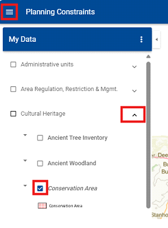
View our web map
Use our web map to view conservation areas in North Norfolk:
- Select the Main Menu drop down with the three lines in the top left corner
- Select My Data
- Select the Cultural Heritage dropdown arrow
- Select the Conservation Area option to display these areas on the map
A to Z of Conservation area maps for North Norfolk
Aldborough to Field Dalling
A
B
Baconsthorpe
Bacton
Bale
Beeston Regis
Bessingham
Binham
Blakeney (also see Glaven Valley)
Brinton (also see Glaven Valley)
C
Catfield
Cley (also see Glaven Valley)
Cromer
D
E
East Barsham
East Runton
Edgefield (also see Glaven Valley)
F
Gimingham to Ludham
G
Gimingham
Glandford (also see Glaven Valley)
Glaven Valley (also see: Blakeney, Brinton, Cley, Edgefield, Glandford, Hempstead, Holt, Hunworth, Letheringsett and Wiveton)
Great Ryburgh
Great Snoring
Gunthorpe
Gunton Park (see also: Thorpe Market)
H
Hanworth
Happisburgh
Helhoughton
Hempstead (see also: Glaven Valley)
Hempton
Hindringham
Holkham
Holt (also see: Glaven Valley)
Horning
Houghton St Giles (also see: Walsingham)
Hunworth (also see: Glaven Valley)
I
Ingham
Ingworth (also see: Mannington and Wolterton)
Itteringham (also see: Mannington and Wolterton)
K
L
Manningham and Wolterton to Stiffkey
M
Manningham and Wolterton (also see: Ingworth and Itteringham)
Matlaske
Melton Constable Park
Melton Constable Village
Morston
Mundesley
N
Neatishead and Hall Road, Barton Turf
North Walsham
Northrepps
O
P
R
S
Salthouse
Saxlingham
Sculthorpe
Sharrington
Sheringham
Sidestrand
Southrepps (Lower)
Southrepps (Upper)
Stalham
Stalham Staithe
Stiffkey
Stody
Tattersett to Worstead Meeting Hill
T
Tattersett
Thornage
Thorpe Market (also see Gunton Park)
Trimingham
Trunch
U
W
Walsingham (also see Houghton St Giles)
Warham
Wells
West Raynham
West Runton
Weybourne
Wighton
Wiveton (also see Glaven Valley)
Worstead
Worstead Meeting Hill
Still need help?
Visit our contact us page for further assistance about our popular services and information.